


Lot n° 274
Estimation :
500 - 700
EUR
Cartography - Atlas - Poland - Silesia
HOMANN... - Lot 274 - Briscadieu
Cartography - Atlas - Poland - Silesia
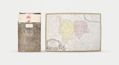
HOMANN (Erben)
Atlas Silesiae id est Ducatus Silesiae generaliter quarteor mappis nec non specialiter XVI mappis tot principatus repraesentantibus geographice exhibitus. Norimbergae [Nuremberg], Homannianis Heredibus, 1750.
20 sheets (plus title page) of color-enhanced maps (with decorative cartouches) mounted on canvas and accordion-folded. Together in a boiled cardboard case with flap and tongue closure. Bookseller's vignette on case ("Librairie Théophile Korn à Breslaw"). On the legible storage side, covered with orange morocco paper, gilded letters "Wieland Atlkas von Schlesien".
The Atlas Silesiae was a large-scale atlas of Silesia, Poland.
Measuring of Silesia began under the reign of Charles VI, by the lieutenant-engineer Johann Wolfgang Wieland (completed in 1732). In 1735, the Homann heirs were commissioned to publish the maps in an atlas. A revision of the maps was undertaken in 1736 by Lieutenant-Engineer Matthäus von Schubarth.
For a long time, the atlas was the only government map of Silesia.
My orders
Sale information
Sales conditions
Return to catalogue